Turn by turn
Westbound Lake Springfield
Printing this description can take a lot of time, so you might want to consider buying commercially available alternatives such as the 8 map set and the EZ66 guide to take along on your trip.
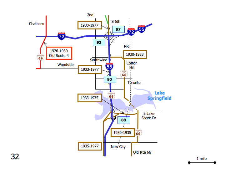
Map courtesy of Stefan Joppich – Legend
| 1926-1930 | 1930-1933 | 1933-1935 | post 1935 |
|---|---|---|---|
| Please see Chatham. | Continue on 6th St.
At the intersection with Hazel Dell Rd. a choice of alignments is available: |
||
|
Warning: This alignment will deadend and require tracing back onto a later alignments. It also uses a lot of connecting road but has an advantage that it allows a peak to see Route 66 as it is submerged under Lake Springfield. We need to avoid the Interstate as Southwind Rd. has no exit from I-55) Right (=west) on Hazel Dell Rd. [connecting] Immediately left (=south) on Hazel Dell Rd. [connecting] Follow as Hazel Dell Rd. curves right (=west) [connecting] Next left (=south) on 2nd St. [connecting] Cross over I-72. Next left (=east) on Canadian Cross Dr. (6th St. Frontage Rd.) [connecting] Follow as Canadian Cross Dr. (6th St. Frontage Rd.) curves right (=south) [connecting] Left (=east) on Southwind Rd. Cross over I-55. Follow as Southwind Rd. curves right (=south) and becomes Cotton Hill Rd. Straight across at the intersection with Toronto Rd. Curve left and right with Cotton Hill Rd. North Cotton Hill: The road is blocked off, one can walk to Lake Springfield. The road passes under a railroad to become submerged under Lake Springfield. Turn around and head north on Cotton Hill Rd. [connecting] Left on Toronto Rd. [connecting] Enter I-55 southbound. [connecting] Cross over Lake Springfield. [connecting] Use exit 88. [connecting]
Left (=east) on Palm Rd. [connecting] Cross over I-55. [connecting] Continue straight on Lake Shore Dr. [connecting] Right (=south) on Olde Carriage Way. The old alignment resurfaces from Lake Springfield just north in East Cotton Hill Park and connected to Lake Shore Dr. 1000 feet more to the north. |
Continue straight on 6th St.
Cross under I-72. Continue onto I-55 south at exit 92. Continue on I-55 past exit 90. Use exit 88. A choice of alignments is available: |
||
| Left on Palm Rd. [connecting]
Cross over I-55. [connecting] Continue straight on Lake Shore Dr. For an abandoned stretch south of Lake Springfield: Turn next left on Lake Shore Dr. This alignment dead-ends on I-55. Right (=south) on Olde Carriage Way. |
Right on Palm Rd.
For an abandoned dead-end stretch: Next right on Lakewood Dr. Immediately right onto the parking lot. Continue past the Marina to find an old route 66 alignment on the western side of the I-55 exit. Dead-ends onto I-55 Continue on Palm Rd. as it veers south. Continue Straight at Chatham Rd. Cross under New City Rd. |
||
| Continue south on Olde Carriage Rd. (old Route 66, CR-125).
Right (=west) on New City Rd. Next left (=south) on Old Route 66. |
|||


