Turn by turn
Statewide eastbound
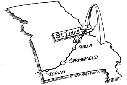
MissouriPrinting this description can take a lot of time, so you might want to consider buying commercially available alternatives such as the 8 map set and the EZ66 guide.
Enter Missouri on SR66 East
Becomes 7th Street into Joplin
The following is a deviation from the signs:
Turn Left (North) onto Rangeline, becomes Madison
Turn Right on MacArthur Blvd. (US-71)
Follow US-71 East / North to Webb City
At Carthage, Take Oak
Left onto Garrison, right onto Central Ave.
Instead, we took:
66 East, past Rangeline, to 71 north.
Leave at 3rd Carthage Exit.
Turn Right onto SR96 East.
Follow SR96, go over Railroad tracks, across Spring River
Head due East on SR96 through Avilla, Stone City, Log City, Rescue,
Phelps, Albatross
At Spencer, take Historic Loop, head towards Halltown
(we missed the historic loop entirely)
At the West end of Halltown, go from SR96 to SR266 East
Continue on SR266 through Halltown, Elwood, Haseltine
Enter Springfield on SR266, becomes Chestnut Expressway East
At ‘Y’, bear right onto College Street.
Left at the next ‘Y’ in the road.
Take St. Louis Street East.
Turn Left onto National, then Left onto Kearny Street.
Kearney Street becomes County Road 00. Follow it straight.
County Road 00 bends Right. Follow it out of Springfield,
Follow 00 NE through Mulroy, Strafford, Holman, Northview.
In Marshfield, take road “CC” North (it branches left)
Follow Road CC through Marshfield, Niangua, Conway, Phillipsburg.
Take Road “W” North, cross I-44. Follow Road W 9 miles.
Go towards ‘W’ fork
Road ‘W’ dead-ends into Elm. Turn Left onto Elm.
Elm becomes Mill Creek. Follow it straight.
Left on Outer road past Lebanon, cross over I-44
Turn left on frontage road
When Road ‘MM’ splits right, bear left to stay on the frontage road.
Join County Road “F” at I-44’s Exit 135, go through Hazelgreen
Take County Road “AB” East through Laquey
Connect to Road “AA”
Right onto Road “P”
Left onto SR17
At I-44 Exit 153, cross to north side of I-44 on SR17
Follow SR17 through Waynesville
The following section was too hard to find, we wound up going
40 miles out of our way. We were running short of time and daylight, so we just jumped on I-40 for awhile. Okay, it’s blasphemy, but hey- Sue me. I’ll go back and do the road again later.
Cross over I-44 before St. Robert, head to Devil’s Elbow
Take South Outer Road (I-44 frontage road) to Arlington
Cross I-44 at Clementine
Enter I-44 at Exit 172, then leave I-44 at Exit 176
Follow South Outer Road past Newburg and Doolittle
Follow BL-44 East through Rolla
BL-44 becomes US63 (Bishop Ave.).
This section was hard to find at night, nothing to see in the dark anyway.
Follow it across I-44, go onto North Outer Road
Follow North Outer Road about 8.5 miles
Cross I-44 at intersection of SR68 (Jefferson)
Continue North on south outer frontage road through:
St. James, Fanning, Cuba, Hofflins, Bourbon, Sullivan.
Road jogs Right at Sullivan, left onto Elmont
Back onto south outer road heading North
Follow North through Stanton, cross to north outer road
Cross to south outer road around St. Clair
Cross north, then south again before Gray Summit
Connect to SR100, pass through Gray Summit, Pacific
Take BL-44 to I-44, enter I-44 at Exit 261
Continue on I-44 through Allenton, Eureka, Peerless Park
Leave I-44 to join Watson road.
Continue on Watson Road through Crestwood, Marlborough.
At St. Louis,
Bear left onto Chippewa Street
Bear left onto Gravois Ave., onto Tucker Blvd.
Follow to 13th Street, to Florissant (Jefferson?),
Right onto Salisbury,
Cross McKinley Bridge (TOLL). The bridge was reported to be in bad shape, but it’s fine. A fully functioning, working bridge.
Description courtesy of Kelly Cash


