Turn by turn
Random point of interest
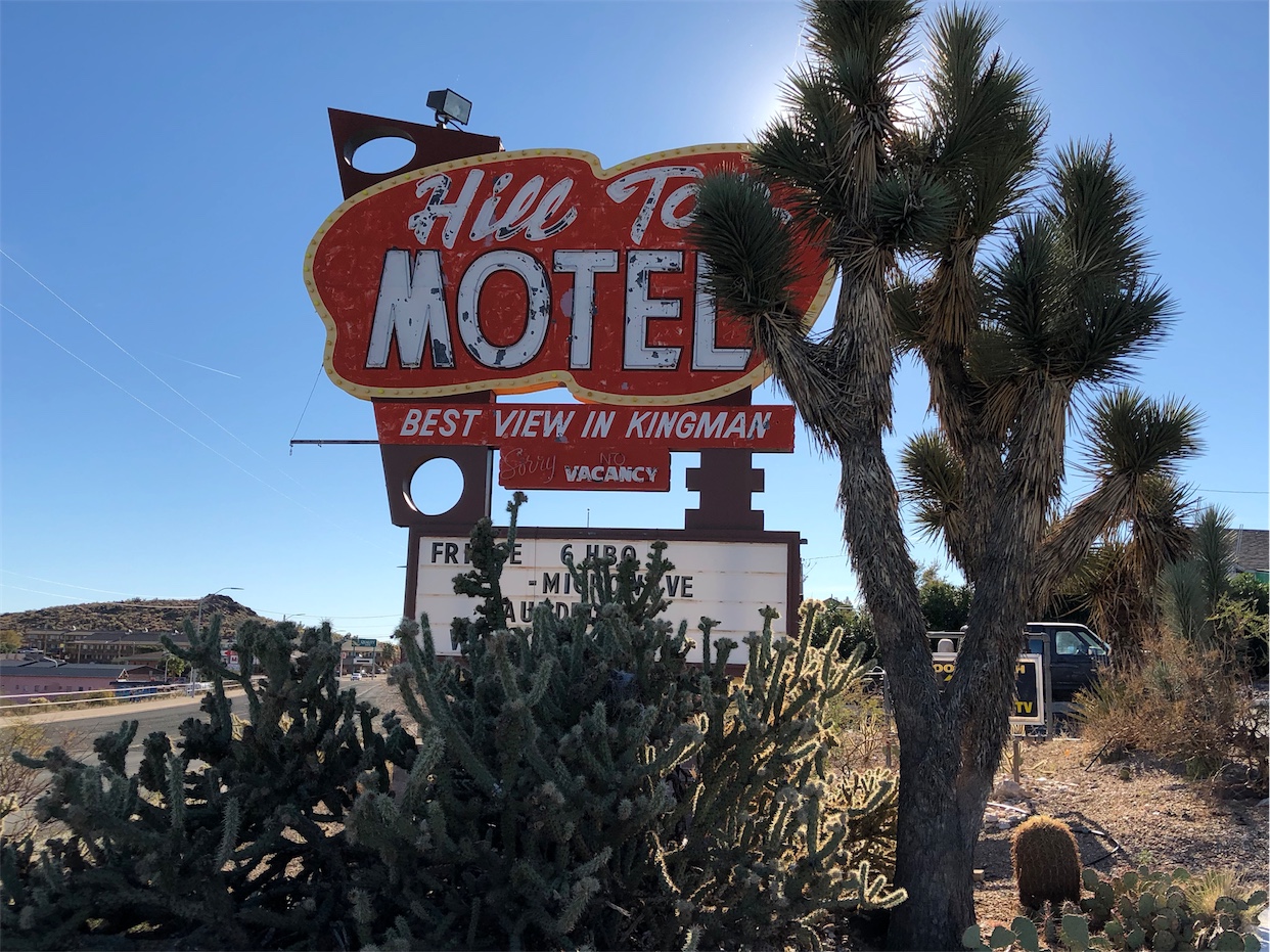
Hill Top Motel
Currently under renovation, this motel opened in 1954 with signage that promised the best view in ...
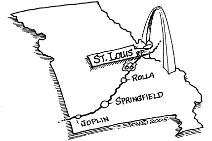
DetailSaint Louis – Sullivan
MissouriPrinting this description can take a lot of time, so you might want to consider buying commercially available alternatives such as the 8 map set and the EZ66 guide to take along on your trip.
Saint Louis
Saint Louis is the largest city on Route 66 between Los Angeles and Chicago. Over the years there have been many different options, a few of them will be all we can handle here.
Many roadies prefer the Watson Road alignment, if only to stop at Ted Drewes.
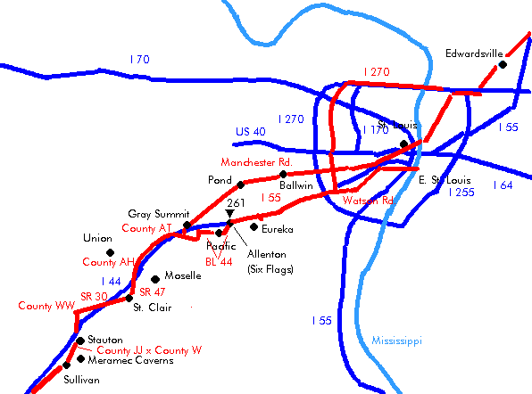
| from McKinley Bridge | from Chain of Rocks Bridge (or I-270) | from McArthur Bridge (or I-55) |
|---|---|---|
|
Currently, McKinley bridge is closed and not expected to reopen before 2006, to get here from I-270, take exit 29 and head south on Florissant Ave., right onto Salisbury St. (situation in 2004). After crossing the bridge, get onto Salisbury St. Cross I-70. Cross Florissant Ave. After 0.25 mile, left onto Palm St. Slight right turn (=south) onto Florissant Ave. Continue on Florissant Ave. After 1.2 miles, make a right (=south) onto 13th St. Follow onto Tucker Blvd. Sidetrip: The Gateway Arch is to the east on Market St. (0.8 miles away). Sidetrip: Union station is a historic train station converted into a shopping mall. Located to the west on Market St. for half a mile Sidetrip: Bush stadium, might be demolished in the future to make room for a more modern stadium. Located to the east between Walnut and Spruce St. Continue on Tucker Blvd. Cross I-64. Continue on Tucker Blvd. Cross the I-55 & I-44 interchange. Continue as Tucker Blvd becomes Gravois Ave. (MO-30). Turn slight right onto Chippewa St. (MO-366). Ted Drewes Frozen Custard, 6726 Chippewa St., on the left side. World renowned frozen Custard. Cross the River Des Peres Drainage Channel in the Willmore Park. Continue as Chippewa St. becomes Watson Rd. (MO-366). ShrewsburyContinue on Watson Rd. (MO-366). MarlboroughContinue on Watson Rd. (MO-366). The historic Coral Court motel used to be here, but it has made place for a new subdivision on Oak Knoll Manor Dr. Webster GrovesContinue on Watson Rd. (MO-366). CrestwoodContinue on Watson Rd. (MO-366). The 66 Park-in (drive-in theater, opened in 1948) used to be at 9348 Watson Road, but was torn down in 1994 and is now replaced by a shopping center. Sunset HillsCross Lindbergh Blvd (US-50), another Route 66 alignment. Cross Geyer Rd. Join I-44 westbound near exit 276. |
One chooses this alignment in order to skirt St. Louis. Chain of Rocks Bridge (closed for vehicle traffic). Due to persistent break-ins in cars it is currently not advised to park your car on the Missouri side of the Chain of Rocks Bridge. It’s safer to first check in to your motel, clean out the car and park on the Illinois side instead. Near the Chain of Rocks Bridge, the Chain of Rocks Amusement Park used to be till it was closed in 1977. The access road paralleling the Interstate has a few old motels left. Bellefontaine NeighborsContinue west on I-270. FergusonContinue west on I-270. For a trip to the McKinley bridge, take exit 29 and turn south onto Florissant Ave. (not Florissant Rd at exit 27)!).; Continue on Florissant for about 9.5 miles and make a left onto Salisbury St. (McKinley bridge (closed) is straight ahead). FlorissantContinue west on I-270 HazelwoodLeave I-270 at in Hazelwood at exit 25A onto Lindbergh Rd. (US-67) (=south). Ford assembly plant on the left. Continue south on Lindbergh Rd. (US-67) Boeing facility on the left. Lambert Saint Louis International Airport on the left. BridgetonContinue south on Lindbergh Rd. (US-67) Cross I-70. Continue south on Lindbergh Rd. (US-67) Maryland Heights/Saint AnnContinue south on Lindbergh Rd. (US-67) Creve CoeurContinue south on Lindbergh Rd. (US-67) Monsanto HQ (left and right) Ladue/FrontenacContinue south on Lindbergh Rd. (US-67) Cross I-64/US40. Continue south on Lindbergh Rd. (US-67) HuntleighContinue south on Lindbergh Rd. (US-67) KirkwoodSidetrip: The National Museum of Transport at Kirkwood, located at 3015 Barrett Station Rd. Continue straight as the road becomes Kirkwood Rd. (US-67) Intersection with Manchester Road (Route 66 Alignment), turn right (=west) to exit Saint Louis this way. Continue further down. Alternatively, continue straight for leaving Saint Louis on Watson Rd. Sunset hillsCross I-44. Continue straight as Kirkwood Rd. becomes Lindbergh Blvd. (US-67) Turn right (=west) onto Watson Rd. Just before the Sunset hills Plaza Shopping Center. |
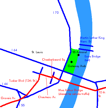
This is an original bridge Route 66 bridge, but it is closed for vehicles. One can use the nearby bridge for I-55 & I-64 instead. The Gateway Arch is on the right, about half a mile away. The arch was built in the mid-sixties but is an ageless monument made of stainless steel. Follow the Interstate system towards I-44 Just north of Chouteau Ave is the endpoint of the closed old Mac Arthur Bridge (route 66). Eat-Rite Diner at 622 Chouteau Ave. Exit at Tucker Blvd. Turn back underneath the interstate Follow Tucker southwest Follow onto Gravois Av. |
|
continue |
||
Out of the city, there are also two different options:
| Manchester Rd. Alignment | Watson Rd. Alignment |
|---|---|
|
Chouteau Ave. Becomes Manchester Ave. after it crosses Vandeventer Ave. Manchester Rd. (MO-100) one of the two ways out of the city, it passes: MaplewoodContinue on Manchester Rd. (MO-100) BrentwoodContinue on Manchester Rd. (MO-100) Rock HillContinue on Manchester Rd. (MO-100) Warson Woods/GlendaleContinue on Manchester Rd. (MO-100) KirkwoodContinue on Manchester Rd. (MO-100) Cross Kirkwood Rd. (US-67), another alignment of Route 66. Des PeresContinue on Manchester Rd. (MO-100) Cross I-270. ManchesterContinue on Manchester Rd. (MO-100) WinchesterContinue on Manchester Rd. (MO-100) BallwinContinue on Manchester Rd. (MO-100) EllisvilleContinue on Manchester Rd. (MO-100) WildwoodContinue on Manchester Rd. (MO-100) GroverWhen Manchester Road splits from MO-100, turn left to stay on Manchester Rd into Grover PondContinue on Manchester Rd. 2.2 miles after Pond, follow Manchester Rd., continue straight on across MO-100 When MO-100 and Manchester Road intersect again (0.8 miles later), reconnect for about 2.3 miles with MO-100 westbound. HollowTurn right onto Manchester Rd Reconnect with MO-100 after 2 miles. Continue on Manchester Rd. (MO-100) Gray SummitCross I-44. Turn right (=west) onto MO-100. The Watson Rd. alignment joins from the left (US-66) |
The highway is bordered by the Henry Shaw Gardenway, named after the founder of the Missouri Botanical gardens in Saint Louis. Sunset HillsOn Watson Rd., westbound. After crossing Lindbergh Blvd (US-50), another Route 66 alignment. Join I-44 westbound near exit 276. Cross Meramac River. FentonContinue on I-44 west Daimler-Chrysler plant on the right. Valley ParkContinue on I-44 west High RidgeContinue on I-44 west Valley ParkContinue on I-44 The frontage road to the north is old Route 66. Sidetrip: The wolf sanctuary (officially Wild Canid Survival and Research Center) is located 25 miles Southwest of St. Louis at Washington University’s Tyson Research Center. From highway 270, take I-44 West to Beaumont/Antire Rd (exit 269). EurekaContinue on I-44 Route 66 State Park at exit 266 (Lewis St.) Route 66 State Park Visitor’s Center at 97 North Outer Road. This area was known before as Times Beach but it got closed due to contamination with dioxin. It’s now cleaned up by the EPA. Black Madonna Shrine. Exit I-44 at exit 261 (Six Flags Rd.). Left across I-44 Right onto Old Highway 66 (I-44-BL). Bridge and major rock cut after 1 mile. PacificRemains of the Beacon motel, short after the rock cut. Continue on Old Highway 66 (I-44-BL). Red Cedar Inn, built in 1934, located at 1047 E. Osage St. Currently closed and for sale [last update: 2005] Continue straight as Old Highway 66 becomes Osage St. (still I-44-BL) Monroe’s 66 diner, located about 1 mile beyond the Red Cedar Inn. Straight at the intersection with Viaduct St., onto Osage St. (Highway 66), near exit 257 where the business loop ends. Continue as the Osage street becomes US-66 Crossing the Union Pacific Railroad, check the bridge and the tunnel towards Gray Summit (northwest). West of Pacific, on the left, is the Missouri Botanical Garden Arboretum. Jensen Point is a scenic overview, named after Lars Peter Jensen, who was manager of the arboretum and the first president of the Henry Shaw Gardenway Association. Gray SummitConnect with MO-100, continue straight at the stop onto MO-100. |
|
continue |
|
Gray Summit
New Diamonds Restaurant and Motel at the intersection of MO-100 and US-66.
The Gardenway Motel, 0.5 miles west of the intersection.
Continue on MO-100, the south service road.
Villa Ridge
pass over I-44
At the intersection of MO-100 and MO-AT, continue straight onto MO-AT (near exit 251).
Tri County Restaurant and truck stop (old Diamonds).
Sunset Motel (1 mile further).
Continue straight at the intersection with MO-M.
Continue straight at the intersection with MO-0 onto MO-AT (MO-M).
Union
Straight across US-50 near exit 247 onto the north service road.
Continue on the north service road at the intersection with Denmark Rd.
Hall’s place 1 mile beyond the intersection.
Stay with the interstate on the north service road as the service road turns onto Indian Prarie.
Moselle
Cross I-44 to the south side near exit 242.
Continue on the south service road.
St. Clair
Continue as the service road become Commercial Ave.
Straight at the intersection with MO-TT.
Continue straight onto Commercial Ave. (MO-47) at the intersection with MO-47.
Just past junction with MO-30, turn north to cross I-44 (at exit 239).
Old Route 66 alignment straight.
Left onto the north service road.
Stanton
Cross to the south side at the junction with road JJ (at exit 230).
Take the south outer road to Sullivan.
Antique Toy Museum
Jesse James Museum
The legendary Meramec Caverns are a few miles onto MO-W. The caverns, said to be a refuge for Jesse James, are a tourist attraction since 1933.
Oak Grove
Continue as the road turns into Springfield Rd.
Continue straight at the intersection with MO185 near exit 226 (do not seek the South service road which is closer to I-44, continue on Springfield Rd.).


