Turn by turn
MO stateline
KansasPrinting this description can take a lot of time, so you might want to consider buying commercially available alternatives such as the 8 map set and the EZ66 guide to take along on your trip.
Kansas has only 13 miles of Route 66, but they are well preserved and worth the time.
Map courtesy of Stefan Joppich
Missouri-Kansas state line
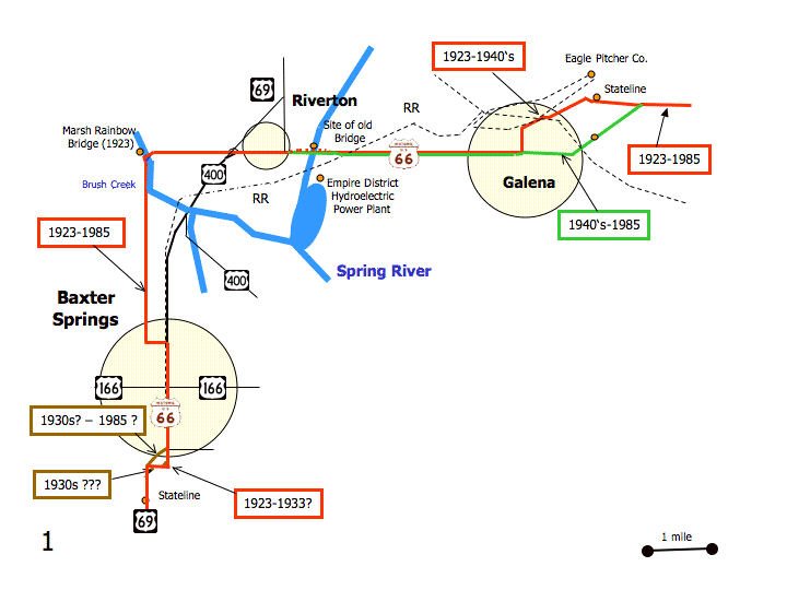
Galena
More on Galena
You are in a former lead and zinc mining area.
Entering from Missouri you had a choice of alignments:
| pre 1940s | post 1940s |
|---|---|
|
This is the 2 lane alignment indicated back in Missouri with the old Route 66 next right sign (recommended) Enter Galena on Front St. Eagle Picher Plant on your right. Cross the viaduct across the railroad tracks. The viaduct you use is of historic significance. Turn left (=south) onto Main St. On your right is the Howard Litch Memorial Park. Turn right (=west) onto 7th St. (KS-66). |
This is the 4 lane alignment. Enter Galena on KS-66 (7th St.) Continue straight at the intersection with Main St. (KS-26). |
|
Rejoin at the intersection of 7th St. (KS-66) and Main St. (KS-26), heading west on 7th St. (KS-66). |
|
The Galena Museum on your right.
Continue on KS-66 (7th St.).
Cross the Spring River.
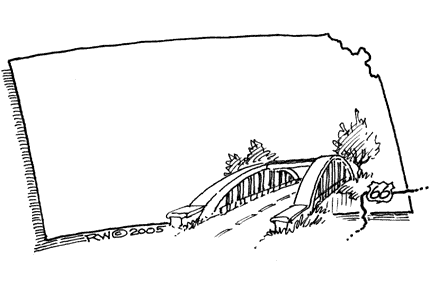
Former site of a multi-span Marsh Rainbow Arch Bridge.
On the left is the Empire District Hydroelectric Power Plant.
Former Spring River Inn: Take a right just after crossing the Spring River.
Riverton
More on Riverton
Continue straight as the road renames to US-69-Alt.
Old Eisler Bros. Store on the right.
At the intersection with US-400, a choice of routes is available:
| pre 1960 | post 1960 |
|---|---|
|
Cross US-400 (US-69-Alt) (slight right and left turns involved) onto Beasley Rd. (Old US Hwy. 66). Straight across the intersection with Academy St. (60th St.). As Beasley Rd. starts to turn south with the Rainbow Arch Bridge in sight, turn right and immediately left to reach the old bridge. Cross over Bush Creek The Marsh Rainbow Bridge over Bush Creek. On the south end of the bridge, turn left and immediately right onto 50th St. Large vehicles might prefer to use the modern bypass from Beasley Rd. to 50th St. Continue on 50th St. (Old US Highway 66). Cross over Willow Creek Former Willow Creek Marsh Rainbow Arch Bridge. Baxter SpringsMore on Baxter Springs Continue as 50th St. becomes Willow Ave. The area was known as “gasoline alley“. Swing left (=east) onto 3rd St in a long curve. Note that 3rd St. comes very close to 2nd St. Turn right on Military Ave. (US-69-Alt) |
Turn left (=southwest) onto US-400. Continue straight on US-69-ALT as US-400 turns left. Baxter SpringsMore on Baxter Springs Continue straight onto Military Ave. (US-69-ALT). |
|
Rejoin at the interstation of 3rd St. and Military Ave. (US-69-ALT). |
|
Up to the late 1930s, Military Ave, featured a street car that connected to Riverton, Galena and Joplin.
Historic site of the Baxter Inn and General Store located on 6th St., just off of Military Ave.
East on 6th St. leads you to the bridge over the Spring River.
Fort Blair, built in 1863 was in the block to the east between 6th and 7th St. It was a union Army post during the civil war and linked to what became known as the battle of Baxter Springs or the Baxter Springs Massacre.
Baxter Springs Heritage Center and Museum at 740 East Ave.
You will find many historic buildings on Military Ave., the Baxter Springs Heritage Center and Museum has a walking tour of them, check it out!
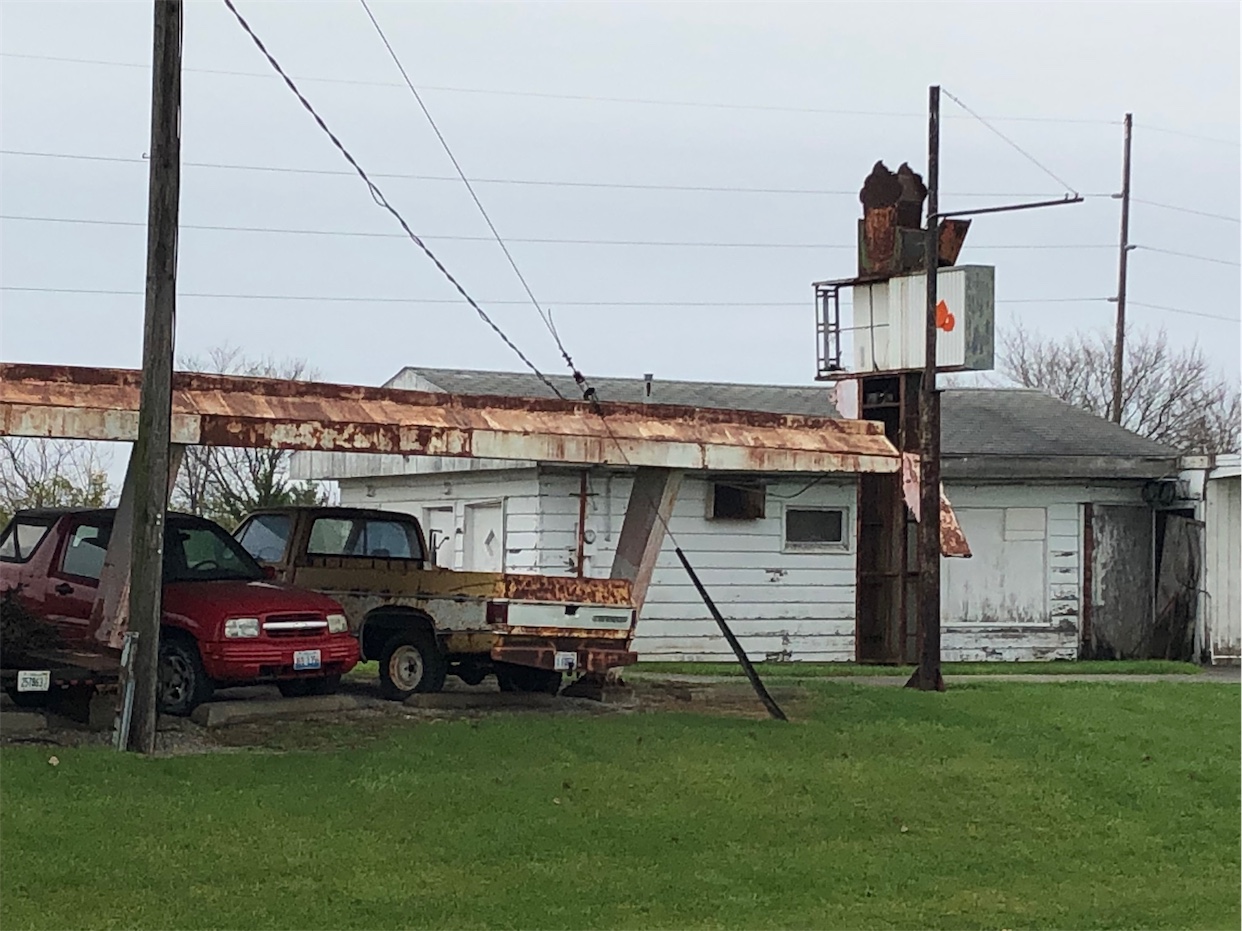
The Phillips 66 gas station at 940 Military Ave. is on the National Register of Historical Places and saw it’s heyday in the 1940s and 50s.
Murphy’s Restaurant is located at 1046 Military Ave. It’s housed in a former bank building (Illinois Cash/Baxter National Bank). This bank is claimed to have been robbed by Henry Starr in 1914.
Cafe on the route / The Little Brick Inn at 1101 Military Ave.
The building at 1112 military used to be the Wells-Fargo station and bus station.
Straight across 12th St. (US-166).
US-166 was one of the “daughters” of Route 66. US-166 runs to US-81 at South Haven, KS to the west (since 1926) and was extended to Springfield, MO in 1945. It’s truncated at I-44, just past the Missouri state line nowadays.
Follow US-166 west for 2 miles to the National cemetery #2.
6 miles to the Tri State Marker.
The American National Bank at 1201 Military Ave.
South of town, a choice of alignments is available for about one block:
| 1926-1933 | 1933-1960s | post 1960s |
|---|---|---|
|
This alignment takes you around the block but the road surface and layout makes the detour worth your while (recommended) Turn left onto Roberts Rd. at the intersection with Powell Rd./Roberts Rd., just before a slight right bend (the start of an S-curve). Follow as Roberts Rd continues due south where Military Ave. tried to force you right. Turn right (=west) onto 30th St. Note the curve on the inside of the intersection: that short stretch of road is called “Old US-66” or “Old US Highway 66” on some maps. Turn next left (=south) onto Military Ave. |
This alignment is the first smoothing of the curve. Turn left onto Roberts Rd. at the intersection with Powell Rd./Roberts Rd., just before a slight right bend (the start of an S-curve). Follow as Roberts Rd. continues due south where Military Ave. tried to force you right. Curve right old Route 66. Note the more angled intersection just a bit further, it’s the older alignment before the curve got smoothened out. Join with 30th. St. (=west). Turn next left (=south) onto Military Ave. |
Continue on Military Ave. |
|
Rejoin at the intersection of 30th St. and Military Ave. (US-69-ALT), heading south on military Ave. (KS-69-ALT). |
||
Abandoned Twilight Drive-In on the left.
Continue south on US-69-ALT.


