Turn by turn
Random point of interest
9-11 Remembrance Garden
Two rusted steel girders from the World Trade Center towers, one 14 ft. high and one 15 ...
DetailSanta Rosa – Tijeras
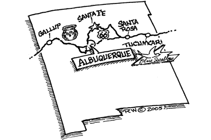
New MexicoPrinting this description can take a lot of time, so you might want to consider buying commercially available alternatives such as the 8 map set and the EZ66 guide to take along on your trip.
Santa Rosa
The Silver Moon Restaurant
Cross I-40 near exit 275.
Ma & Pa Motel on the right.
Tower Motel on the left.
Club Cafe on the right.
County courthouse a bit to the south at 5th St.
Straight across the intersection with 4th St.
Movie theater on 4th St (pre-1939 alignment).
Johnson Wharehouse on the right.
Comet Drive-in.
Coronado Court Motel.
Cross the Pecos River.
Curve right at the intersection with US-54 onto BL-40 (Historic Route 66)
Pat’s Apartments on the left.
Pass under the railroad.
The railroad underpass is the Santa Rosa RR bridge.
Continue northwest on BL-40 (Historic Route 66).
Enter I-40 westbound at exit 273.
A left onto Riviera Rd. puts you on a dead-end alignment of Route 66.
Pre-1937 alignment: into town is La Pradira Ave.; Turn right onto 4th St., turn left onto later alignment.
Out of town there is a rumored pre 1937 alignment ran straight towards Dila, that road is abandoned.
Use exit 267 from I-40 (To Colonias).
The eastward frontage road is a Route 66 alignment, one can drive a bit more than 2 miles east on it.
Rejoin I-40 at exit 267.
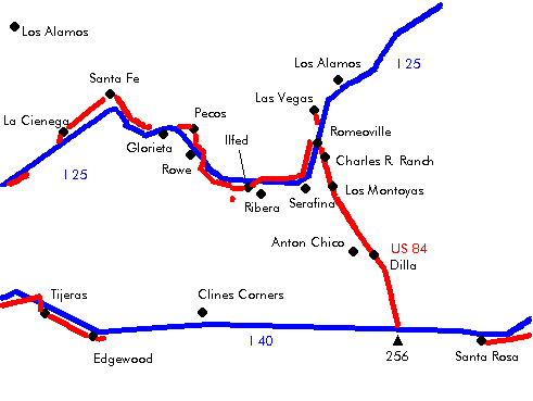
Las Vegas Junction
Choose here between alignments, the consequences of that choice will go on for many miles, so choose wisely:
| Pre 1937 alignment | Post 1937 alignment |
|---|---|
Pre 1937 alignmentUse exit 256 (To Las Vegas). Turn north on US-84 (Historic Route 66). DillaContinue north on US-84 (Historic Route 66). Los MontoyasContinue north on US-84 (Historic Route 66). Charles R RanchContinue north on US-84 (Historic Route 66). RomeovilleContinue north on US-84 (Historic Route 66). Cross over I-25. turn left onto US-84, while avoiding the I-25 on-ramp Serafina/BernalContinue on US-84 on the north side on I-25. Ribera/San JoseContinue on US-84 on the north side on I-25. Ilfed/SandsCross to the south side of I-25 at exit 319. RoweCross I-25 to the east side near exit 307. Continue on NM-63 northbound on the eastern side of I-25. PecosTurn left onto NM-50 at the intersection with NM-50/NM-223. Continue east on NM-50. GlorietaTake I-25 at exit 299. CanoncitoUse exit 294 (Canoncita) Continue west on the north frontage road (NM-300, Old Las Vegas Hwy.) towards Santa Fe. There are sources labeling Old Santa Fe trail (more to the east) as an alternative to Las Vegas Hwy./Old Pecos Trail as an alignment into Santa Fe. Santa Fe
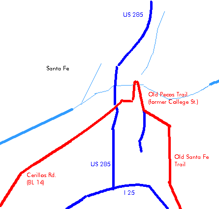
Turn right onto Old Pecos Trail (NM-466) near exit 284. Continue slight right (=north) at the intersection with St. Michael’s Dr. (NM-466) onto Old Pecos Trail. Continue slight left (=north) onto Old Santa Fe trail as it joins from the right. Cross straight at the intersection with Paseo De Peralta (NM-589). Sate Capitol on the left at next intersection. San Miguel mission on the right at 401 Old Santa Fe Trl. The oldest house in Santa Fe on the right at the intersection with De Vargas St. (215 E De Vargas St.). Cross straight ahead at Alameda St. Turn next left onto Water St. Turn left onto Galisteo St. Turn slight left onto Cerrillos Rd. (NM-14). The Wheelwright Museum has Native American pottery exhibited. Also the International Folk Art Museum is nearby. Admission is either nominal or by donation. Downtown is one of the older dwellings in the US, from the early 1600s. Continue south on Cerillos Rd. (NM-14). La Cienega |
Continue on I-40 past exit 256. See old route 66 bridge from the current bridge over I-40. just east of the rest area at exit 252. Flying C RanchContinue on I-40 past exit 234. PalmaPalma was located on US-66 and NM-3 Continue on I-40 past exit 230. Clines CornersThe service station of Roy Cline moved a number of times as alignments shifted. Continue on I-40 past exit 218. Wagon wheelContinue on I-40 past exit 208. Longhorn RanchThe longhorn ranch was a favorite stop and gave a old west feeling. Today only remains can be seen. Route 66 serves as southern frontage road (dead-ends). The owner of the longhorn Ranch once razed the buildings and left them in a disastrous looking state to show his contempt over his neighboring adult establishment. Continue on I-40 past exit 203. MoriartyUse exit 197 (Moriarty) onto BL-40 (NM-333, Route 66 Ave.). Follow BL-40 (NM-333, Route 66) through Moriarty Moriarty is executing a landscaping project on Old Route 66 (spring 2004) Sunset motel on right Whiting Bros. service station on right Siesta motel on left Continue straight across the intersection with Howard Cavasos Blvd. (NM-41). Former Crossley Place (now shoe show). Sands motel on left Old Yucca Motel (closed in spring 2004) on right Old Cactus Motel (a mall in spring 2004) on left Lariat Motel on left. Ponderosa Motel on left. Route 66 Motel on left. Route 66 shopping center on right. At the west end of town , just before the I-40 interchange, turn left onto NM-333 (Highway 66) westbound. EdgewoodContinue on NM-333 (Historic Route 66). BartonContinue on NM-333 (Historic Route 66). SedilloAlternative: An older than the final alignment is going north for a loop here: Continue on NM-333 (Highway 66). ZuzaxContinue on NM-333 (southern frontage road). TijerasContinue on NM-333 (Highway 66). |
|
continue |
|