Turn by turn
Random point of interest
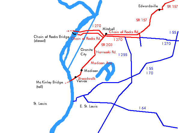
Oklahoma State Capitol
Built in 1917, the Greco-Roman structure was topped with a dome in 2002 and houses murals and ...
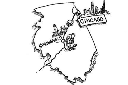
DetailSpringfield – Saint Louis
IllinoisPrinting this description can take a lot of time, so you might want to consider buying commercially available alternatives such as the 8 map set and the EZ66 guide.
Springfield
Lincoln lived in Springfield until he departed in 1861 for the white house.
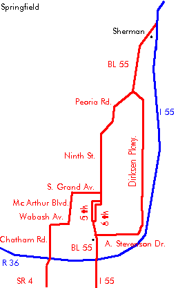
Follow Business Loop 55 into Springfield.
In city loop alternative: Left on Dirksen Pkwy.
After 6 miles, right on Stevenson Dr.
Left on Business Loop 55 (6th St.).
Continue straight on BL-55 (Peoria Rd.).
Pioneer Motel, 4321 N Peoria Rd.
After 1.3 miles, Continue left (=south) onto BL-55 (Peoria Rd.) ignore the recent alignment of IL-4 that continues straight.
After 0.3 miles, continue straight on Peoria Rd., do not turn right on Traintor Rd (Traintor Rd. is an old alignment of IL-4, not of Route 66).
Bill Shea’s Gas Station museum at 2075 Peoria Rd.
Turn left (=south) onto 9th St. (BL-55).
Sidetrip: Lincoln Tomb State Historic site at 1500 Monument Ave. Visit president Lincoln, his wife and three of their sons last resting place, part of the Oak Ridge Cemetery (1 mile to the west of 9th St. ).
Continue straight across N Grand Ave.
Continue south on BL-55.
Turn right (=west) on Enos Ave.
The 1932 bypass continued south on 9th St. all the way to S. Grand St.
Turn left (=south) on 5th St. (Route 66 originally used 6th Street, but that is nowadays one way northbound).
Lincoln’s home, at 8th and Jackson, is now a National Historic Site. It is the only home Lincoln ever owned, and it’s where he gave his “farewell address”.
Old State Capitol between 5th and 6th St. at Adams St.
Lincoln’s office, at 209, S 6th St.
Coney Island Restaurant, 210 S 5th St.
Sunrise Donuts, out of business was located at 1101 S 9th St., on the 1932 bypass.
Steak ‘n Shake at 2100 S. 6th Street.
| 2 lane road [1926-1930] | 4 lane road [1930-1977] |
|---|---|
|
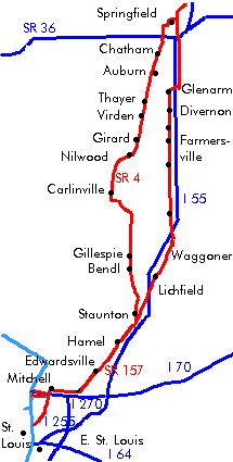
While this is the oldest alignment of Route 66, many prefer the other alignment. This alignment also predates Route 66, under the SBI-4 name. Use old IL-4: In Springfield, Turn right (=west) onto Capitol Ave. Turn left (=south) onto 2nd St. Turn right (=west) onto S. Grand Ave. (IL-54) [not N. Grand Ave.!] Turn south onto Mac Arthur Blvd. (IL-54, former W. Grand Ave.). Turn west on Wabash Avenue. (IL-54) [actually Mac Arthur Blvd. blends right into Wabash Ave.] Turn south (=left) on Chatham Road. Cross over I-72. Route 66 Drive-in at 1700 Recreation Dr. (east on Old Chatham Rd.). Turn right (=west) on Woodside Rd. (CR-23, Spaulding Orchard Rd.). Turn left (=south) onto IL-4 (Veterans Pky.). ChatmanContinue on IL-4. AuburnContinue on IL-4. Red Brick alignment ThayerContinue on IL-4. VirdenContinue on IL-4. Mural GirardContinue on IL-4. Deck’s Drugstore, opened in 1884, now closed. NilwoodContinue on IL-4. CarlinvilleContinue on IL-4. GillespieContinue on IL-4. BenldContinue on IL-4. SawyervilleContinue on IL-4. StauntonContinue on IL-4. Continue straight on Edwardsville St (IL-4). Follow Right onto North St. Immediately left onto Hibbard St. (=south). Cross Main St. Right onto Pearl St. (IL-4). Left onto Hackman St. (=south). Continue on Hackman St. as it turns right (=west). Turn left onto IL-4 (=south). Continue straight as the 1930-1940 Alignment joins at Williamson Rd. Near exit 33 of I-55: Continue straight on IL-4, crossing the 1940-1977 alignment (frontage Rd.). Cross I-55. Turn right onto IL-140 (=west). Cross I-55 at exit 30. The 1930-1940 directions send you here in the opposite direction for about half a mile! HamelTurn left onto IL-157 (Old US Route 66). |
Straight across S. Grand Ave.
Continue as 5th St. veers left and become southbound 6th St. Continue on 6th St. (BL-55). Bel Aire Motel, 2636 S 6th St. Cozy Drive Inn, 2935 S 6th St. Continue onto I-55 south at exit 92. Lake Springfield (manmade, 30’s) now covers parts of an old 2 lane alignment of Route 66. Remnants are to be found east of I-55, near exits 90, 88 and 83. Some parts of old 66 are now under the normal water level of Lake Springfield, when the water level is low, the road can sometimes still be seen. On I-55, use Chatham exit (exit 88). Turn right on Palm Rd. after 0.15 mile, turn right, followed by an immediate right to find an old route 66 alignment on the western side of the I-55 exit. Continue on Palm Rd. as it veers south. Continue as Palm Rd. becomes Douglas St. Continue as Douglas St. becomes Frazee Rd. GlenarmContinue on Frazee Rd. past exit 83. After Glenarm, turn left onto IL-104. Join on I-55 south at exit 82. See old Route 66 on the right between exit 82 and 80. DivernonTake exit 80 on I-55 to Divernon. Right onto Brown st. Next left onto the Frontage Road (Reichert Rd.). Continue on the western Frontage Rd. ThomasvilleContinue on the western Frontage Rd. FarmersvilleEnter Farmersville on the western Frontage Rd. Continue on the western Frontage Rd. past exit 72 of I-55. Leave Farmersville on the western Frontage Rd. Art’s Motel and Restaurant WaggonerContinue on the western Frontage Rd. 1.7 miles further, continue past the rest area. “Our Lady of the Highways”, near Raymond (1.5 miles beyond the rest area), is a marble statue of the Virgin Mary. Continue on the western Frontage Rd. past exit 63. RaymondContinue on the western Frontage Rd. past exit 60. At the intersection of the frontage road and IL-108, Holiday-inn, a unique one with a steamboat on a lake. This place is not part of the hotel/motel chain. Litchfield3.3 miles beyond exit 60, turn left at 1600 North. Cross I-55 (no exit). Right onto the eastern frontage road into Litchfield. Some sources label the eastern frontage Road as Route 66 north of this as Route 66 as well. Sidetrip: The Honey Bend Resort in Litchfield is an ideal resort for fishermen. Sidetrip: Lake Lou Yaeger is a 1500 acre lake, a nice place for family picnics, boating, camping, fishing… Continue on the frontage road (BR-55, US-66) on the eastern side of I-55. As Route 66 continues straight where the tracks turn left, an older alignment continues left along the tracks. Cross the railroad tracks 1930-1940 Litchfield alignmentTurn left(=east) onto Sherman St. (=south) Sky View Drive-In on the left. Continue straight across IL-16 onto Sherman St. Ariston Cafe beyond the intersection with IL-16 (Union Ave.) at 413 N. Sherman St. Route 66 Cafe a bit over half a mile further at 318 S. Old Route 66. Continue south as Sherman St. turns into Old Route 66. South of Litchfield, rejoin the 4 lane alignment (US-66, I-55 BR). 1940-1977 Litchfield alignmentStay on the 4 lane alignment through town. Mt. OliveMount Olive used to be a coal-mining center in the early 20th century. In the northwest of town, is the cemetery. Near the entrance is a memorial to “Mother Jones” (1830-1930, born Mary Harris), a famous union activist. Her grave can also be found in the cemetery. 1930-1940 Mt. Olive AlignmentAs US-66 turns right, away from the railroad, make a left onto old Route 66 (former Mt. Olive Rd.). Follow as the road turns right (=west) onto 5th St. Follow as the road turns left (=south) onto Illinois St. (Old Route 66). Continue straight across IL-138. Old Soulsby Shell station (1926-1991), being restored and destined to become a museum (2003). Note the 5 doors and the tree growing inside the drive-up ramp. Located on Illinois St., 0.1 miles south of the intersection with IL-138. South of Mt. Olive, turn left onto the 4 lane Route 66 alignment (frontage road). 1940-1977 Mt. Olive AlignmentContinue straight onto US-66 as it skirts Mt. Olive. At the intersection of the frontage road and old Route 66 on the right: 1930-1940 through StauntonTurn right onto Old Route 66 towards Staunton. Continue straight across the intersection with Staunton Rd. StauntonFollow left onto Bentrup Rd. Flow right onto Route 16 Rd. (large bend). Follow right onto Henry St. (=west). Follow left onto Route 16 Rd. (=southwest). Turn left onto Madison St. (=south). Continue as Madison St. turns into Sievers Rd. Turn right (west) onto Williamson Rd. Turn left onto IL-4 toward Hamel. Henry’s Rabbit Ranch located at 1107 Historic Route 66. 1940-1977 through LivingstonContinue straight on the frontage road. At Staunton Rd., turn Right (=west). Cross I-55 at exit 41. Turn left onto the western frontage road south. LivingstonContinue as the frontage road turns right (=west) and becomes Church St. Turn left onto Park St. Continue as Park St. turns right and becomes Veterans Memorial Dr. Continue on the frontage road towards Hamel. Near exit 33: Straight across IL-4 (another Route 66 alignment). Next left onto the frontage road. Continue as the frontage road turns into Old Route US 66 approaching Hamel. |
| continue | |
Hamel
Church of the Neon Cross: Dedicated to Saint Paul, featuring a huge blue neon cross.
Meramec Caverns advertising barn, known as the Hamel Barn, restored in 2001 by the Illinois Historic Route 66 association.
| [1926-1940] | [1940-1977] Alignment | ||||||
|---|---|---|---|---|---|---|---|
| Continue straight onto IL-157 (Old US Route 66) at the intersection with I-140 (State St.).
Many Route 66 travelers prefer this alignment over the I-55 alignment due to being able to stop and see more things along the way. EdwardsvilleFollow IL-157 till just before I270, turn onto Chain of Rocks Road westbound (=right). Mustang Corral: At the crossing of IL-157 and Chain of Rocks Road is a large lot with about 200 Mustangs waiting for a second life. Address: Mitchell
Luna cafe, a former hangout for shady characters. The neon sign is being restored (spring 2004). Land of Lincoln Motel Chain of Rocks Motel
|
Turn left at the intersection of Old Route 66 and I-140.
enter I-55 southbound at exit 30. Picking up from Hamel. CollinsvilleSidetrip: The Brooks Catsup Bottle in town dates from 1949. It’s located south of Main St. on IL-159. Exit I-55 at exit 15A towards Collinsville. Head south on Vandalia St (IL-159). At the first intersection (St. Charles Dr.), turn left to find the old 4 lane alignment (Troy Rd.) that linked present-day Vandalia St and the Interstate. After about 1.5 miles, turn right (=west) onto Belt Line Rd. Continue on Belt Line Road as it crosses under I-55. Next left onto Bluff Rd. (=south) (IL-157). Cross I-55 near exit 11. A later alignment used I-55 till this point skipping the previous parts. After about 1.5 miles, turn right (=west) onto Collinsville Rd. Continue on Collinsville Rd. Cross under I-255. Fairmount Park (horse races) on the right. Continue on Collinsville Rd. The Cahokia Mounds State Historic Site is located a few miles west of Collinsville. Here you can find the remains of a large prehistoric native civilization. Fairmount CityContinue on Collinsville Rd. Continue straight at the intersection with IL-111. Continue on Collinsville Rd. Continue straight at the intersection with IL-230. East Saint LouisWARNING: west of I-64 the area was very much to be avoided (summer 2004) as it does not feel a safe place to be in at all, I strongly recommend to skip it. If you want to skip it, join I-55 by turning right on IL-230 and joining I-55 westbound at exit 4. Skip these few miles of old Route 66, and take the Interstate, it was Route 66 as well at one point. Continue straight as Collinsville Rd. becomes 9th St. Cross under the railroad tracks. At the split between 9th and 10th St. keep on 9th St. Cross over I-64. WARNING: (summer 2004) This area did not feel safe and I’d suggest not to attract attention out here. If you feel unsafe, please head to the Interstate as soon as possible (as I did). Due to this, the notes on this area aren’t reliable either. Immediately turn right on St. Clair Ave. Turn left before the interstate onto Collinsville Ave. Route 66 turned right onto St Louis Ave. towards Veteran’s Memorial Bridge [renamed to Martin Luther King Memorial Bridge] (not possible anymore: St. Louis Ave. is blocked by the interstate) One block before St. Louis Ave., turn north on Martin Luther King Dr. Continue on Martin Luther King Memorial Bridge to enter Missouri. |
||||||