Turn by turn
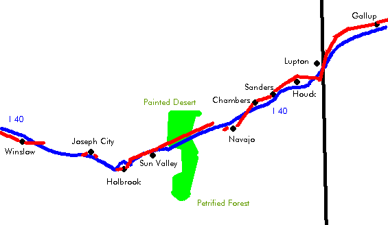
Lupton – Winslow
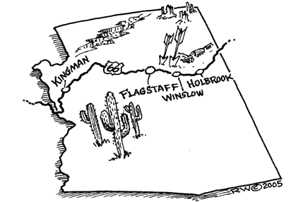
ArizonaPrinting this description can take a lot of time, so you might want to consider buying commercially available alternatives such as the 8 map set and the EZ66 guide to take along on your trip.
Enter from New-Mexico on the northern frontage road.
After 0.5 miles, turn left on Grants Rd.
Cross I-40 to the south at exit 359.
Turn right to continue westbound on the southern frontage road.
Lupton
Continue straight at the intersection with BIA-12/BIA-9402 near exit 357 (Lupton).
Continue west on the southern frontage road.
Continue west to exit 354 (Hawthorne Rd.)
Join I-40 for an easier alignment at exit 354 till 351.
Continue on the southern service road past exit 354.
If you can, cross to the north at one of the underpasses, otherwise continue to exit 351 and get to the north there.
Continue on the northern frontage road (1931 alignment).
Allentown
Continue on the northern service road at the intersection with Allentown Rd.
There is a real old alignment to the south (dirt road) that routes south of the Pecos River towards Sanders along road 7240, bypassing a few places.
Continue on the I-40 till exit 339 (is a late Route 66 alignment.
Continue on the northern frontage road.
Houck
An alternative to driving on dirt roads is to drive on I-40.
Continue straight across St. Anselm Rd. onto the northern frontage road.>
Continue as the frontage road becomes a dirt road (Querino Dirt Rd.)
Continue straight at the intersection with Pine Springs Rd. near exit 346.
Big arrow Rd should be around here as well.
Old Querino Canyon Trading Post (ruins)
pass over the Querino Canyon Bridge
Continue straight onto Quenno Dirt Rd. at the intersection with Querino Rd.
Join I-40 at exit 341 (Cedar Point)
Continue straight at the intersection with Cedar Point Rd. onto the northern frontage Rd. (Old Rt. 66) (dead-end).
Sanders
Use exit 339 (Sanders) from I-40.
The old route 66 bypass from Allantown returns here from the south (turn left onto US-191 and join here).
Continue on the northern frontage road (McCarroll Rd.).
Continue as the northern frontage road becomes CR-7060 (McCarroll Rd.).
Chambers
At the junction of the north frontage road and US-191, turn left to reconnect with I-40 (exit 333)
McCarrol Rd. straight ahead towards exit 330 was Toute 66 as well (private property).
Rejoin I-40 westbound to exit 333.
Continue on I-40 at exit 330.
From the north McCarrol Rd joins here.
Navajo
Continue on I-40 at exit 325.
An old alignment is 0.5 miles to the south of here, very bad conditions, better not to drive.
This road cross I-40 a bit further and wil to the north of exit 325.
Continue on I-40 at exit 320 (Pinta Rd.).
To reach where the Route 66 dead-end on the east side of the petrified forest:
Travel north on Pinta Rd. for about 1 mile.
Turn left (=west) onto Road 66.
(right =east) is also Route 66, it’s the road that started at exit 330 Follow as the road curves right.
Note the ruins of the Painted Desert Trading Post.
Cross the Dead Wash.
Follow as the road curves left.
Continue on this road till the fence of the park.
Return to I-40, no access into the park at this point.
There is an even older alignment more to the south of present I-40: It follows the railroad more to the south (through Pinto).
Continue on I-40 at exit 311 (Petrified Forest National Park).
Painted Desert: colored sand, beautiful views.
Petrified Forest: 225 million years ago, these trees grew here, now they are colorful stones.
The “long logs” area is the most interesting.
There is a 28 mile drive showing many aspects of the park.
At Kachina Point is the Painted Desert Inn, a building worth a long history.
note: It is illegal to remove almost anything from the park. When exiting the park, take US-180 (former US-260) towards Holbrook.
Although the road itself is gone, the scars of Old Route 66 can be seen in the park along the telephone poles just north of I-40. Note: the biggest clusters of petrified wood are to the south, don’t shoot all that film on the first log, there’s more to come.
continue westbound on I-40 at exit 303.
Cross to the south on Sun Country Rd.
Turn right towards the east:
Continue on the southern frontage road (Old Route 66) till the dead-end. Site of Rocky’s Old Stage Station.
Turn left towards the west:
The southern frontage road was Route 66, but you’ll have to head back at exit 300.
The Painted Desert Indian Center is located here.
Goofy looking dinosaurs advertising Stewart’s petrified wood shop.
Continue westbound on I-40 at exit 300.
There’s an old Route 66 alignment on the north that is on private property, admire from a distance, no access.
Sun Valley
Continue westbound on I-40 at exit 294.
Turn north on Sun Vally Rd. for 0.5 miles.
Turn right onto Pima St.
The feeling for the old road is lost here, but it is Route 66 after all, See the old alignment east.
Continue westbound on I-40 at exit 292.
The International Petrified Forest/Museum of the Americas/Dinosaur Park is here. Not related to the national park service, still quite a collection. The dinosaurs can be seen from I-40.
Holbrook
Leave I-40 at exit 289.
Turn right onto Navajo Blvd (BL-40).
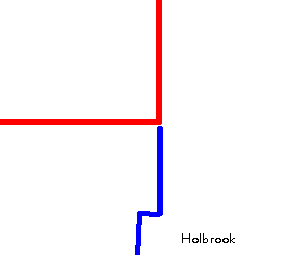
Cross under I-40 at exit 286 to continue on Navajo Blvd. (BL-40, AZ-77).
Rainbow Rock Shop, featuring dinosaurs to attract attention.
Turn right onto Hopi Dr. (BL-180, US-180).
Wigwam motel on the left, renovated in 1988 it’s one of two wigwam motel on Route 66, the other is in Rialto, CA. (actually still in San Bernardino). The slogan “Sleep in a Wigwam” used to work through the kids in the car.
Join I-40 westbound at exit 285.
Continue on I40 at exit 283.
Continue on I40 at exit 280.
Geronimo Trading Post.
Joseph City
Use exit 277 to leave I-40.
Turn right onto BL-40 (Main St.).
Enter I-40 westbound at exit 274.
Continue on the south frontage road at exit 274 to reach after 3 miles a feed store built in the form of a teepee. A bit further is former Ella’s Frontier (old trading post).
Continue on I-40 at exit 269.
Jack Rabbit Trading Post is located at exit 269. You’ve seen a few of the signs advertising the Jack Rabbit by now.
Continue on I-40 at exit 264.
Hibbard Rd. (both directions) was Route 66, but it’s not drivable.


