Turn by turn
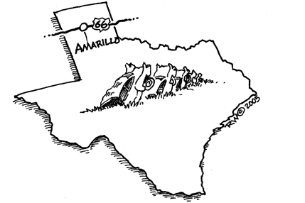
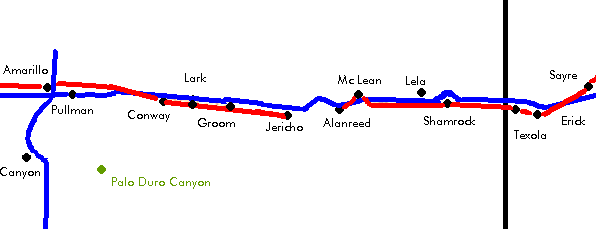
Texola – Amarillo
TexasPrinting this description can take a lot of time, so you might want to consider buying commercially available alternatives such as the 8 map set and the EZ66 guide to take along on your trip.
Texola
Texola is actually in Oklahoma, not in Texas.
Mileage: 0
use the south frontage road
Enter Texas on TX-30-Spur heading northwest from Texola. TX-30-Spur is a 4 lane alignment.
Benonine
The town Benonine moved to Shamrock as it failed to grow.
Continue on TX-30-Spur.
Turn left just before crossing I-40 near exit 176 to take the south frontage road.
Continue westbound on the southern frontage road.
Fuller
Fuller is located to the north of I-44.
Continue westbound on the southern frontage road.
Continue straight at the intersection with Carbon Blank Rd. (FM-1802) near exit 169.
Continue straight at the intersection with FM-2168/CR-21 near exit 167.
Shamrock
The southern frontage road becomes BL-40 near exit 164.
Continue on 12th St. (BL-40).
Continue straight on 12th St. (BL-40) at the intersection with Main St. (US-83).
U-Drop-Inn Restaurant and service station (with art-deco tower): at the intersection with US-83, dating from 1936, an example of art-deco.
Pioneer West Museum, located at 204 M. Madden in the historic Reynolds Hotel (1925), gives a view on how life was here before.
Continue on 12th St. (BL-40).
Econolodge (east)
The Texan Route 66 Motel (west)
At the west end of the city avoid entering I-40 and use the south frontage road.
Continue straight on the southern frontage road at the intersection with CR-14/FM-2474.
Continue straight on the southern frontage road at the intersection with CR-12.
Lela
Continue straight on the southern frontage road at the intersection with FM-1547/FM-3047 near exit 157.
Lela itself is on the north side of I-40 at exit 157.
Rattlesnake sign
Continue straight on the southern frontage road at the intersection with CR-10.
Continue straight on the southern frontage road at the intersection with CR-7.
Continue straight on the southern frontage road at the intersection with CR-6 near exit 152.
Continue past the rest area on I-40
Sources differ on exactly where to cross to the north frontage road:
| near exit 148 | near exit 146 |
|---|---|
| Turn right on FM-1443 at the intersection with CR-3/FM1443 near exit 148.
Cross I-40 to the north. Turn left onto the northern frontage road. Continue straight on the northern frontage road at the intersection with CR-1. Continue straight on the northern frontage road at the intersection with County Line Rd./McCarty St near exit 146. |
Continue straight at the intersection with CR-3/FM1443 near exit 148.
Turn right onto County Line Rd. (McCarty St.) at the intersection with County Line Rd./McCarty st. near exit 146. Cross I-40 to the north. Turn left onto the northern frontage road. |
| continue | |
Continue on the northern frontage road.
McLean
Follow the curve around the off-ramp at exit 143.
Make a right (=northwest) onto BL-40 (Old Route 66) into Mc Lean.
Continue straight on 1st St. (BL-40, Old Route 66).
Devil’s Rope Museum, admission is free, Route 66 display maintained by the Old Route 66 Association of Texas.
Continue straight across Main St.
The first (restored) Phillips 66 gas station.
Cactus Inn (west side)
through town westbound traffic follows 1st St., eastbound traffic would follow Railroad St.
Straight across at the intersection with TX-273 (Sitter St.).
To rejoin the south frontage road, 2 options are available:
| 1 | 2 |
|---|---|
|
Some sources do not recommend this alignment when wet. After 0.2 miles, turn left (=south) onto 26 1/2 Rd. Continue straight across the intersection with the northern frontage road where the other alignment joins from your right. |
after 1.1 miles, turn left (=south) onto CR-26 to avoid entering I-40.
Continue as it curves left (=east) onto the northern frontage road. Turn right towards the underpass of I-40. |
| continue | |
Continue underneath I-40.
Continue as the road curves west again on the southern frontage road.
From Mc Lean to Alanreed, there still exists an old (used till 1932) dirt road, it is located more to the south:
Go to the south on TX-273.
Cross I-40.
1 mile further south, turn right onto BB Rd. (Old US highway 66).
Continue straight west for 2.2 miles.
Follow BB Rd. (old US highway) for 1 mile as it curves to follow the railroad.
Turn right to stay on BB Rd. (Ranch Road 177).
Follow BB Rd. as it curves left and right to follow the railroad.
Straight across FM-291.
Continue on BB towards Alanreed. (details are a bit unclear, check locally)
As with any dirt road: be careful!
Continue on the southern frontage road.
Continue straight on the southern frontage road at the intersection with 23rd Rd.
Alanreed
Continue straight onto TX-271-Loop (FM-291, old route 66) at the intersection with FM-291.
Oldest Cemetery on Route 66 in Texas.
Oldest Baptist Church on Route 66 in Texas.
66 Super Service
Remains of the Reptile Ranch.
West of Alanreed, beyond the I-40 off-ramp, route 66 becomes unpaved for about 1 mile. It was part of the infamous “Jericho Gap”, which was not bypassed till the late 1930’s. It featured car trapping mud. The complete Jericho Gap was 18 miles long. Today most of what is left of the Jericho Gap is private property. Join I-40 at exit 132 when meeting Johnson Ranch Rd. It’s unclear if this is safe, or allowed to do!
The rest of the Jericho gap is harder to reach. It was more to the south and passing through a place called Rockledge.
Jericho
Take exit 124, cross I-40 to the south side and continue 1 mile south to check the endings of both the Jericho-Alanreed and Groom-Jericho sections of the Jericho gap.
Groom-Jericho cut-off to the south of I-40. Private property.
Return to I-40, enter westbound at exit 124.
The southern frontage road could be used as well.
Take exit 114.
Turn left onto BL-40 (Old Route 66).
Turn right with BL-40 (Old Route 66) towards town.
Groom
Continue on BL-40 (old Route 66, Frontage St.).
Leaning water tower, designed so to attract visitors, and still successful at it.
The largest cross in the western hemisphere is located in Groom.
Turn left just before BL-40 rejoins I-40 at exit 110 on the south frontage road.
Lark
Continue west on the southern frontage road.
What is left of Lark is located to the north of I-44 at the intersection with CR-V/FM-2880.
Continue west on the southern frontage road.
At the intersection with CR-O/TX-207, continue straight onto TX-207 (US-66).
Conway
Continue straight at the intersection with TX-208/CR-N onto FM-2161 (US-66).
The Bug Farm, 5 Volkswagen Bugs buried nose down next to the trading post.
Continue straight for about 5 miles.
Follow FM-2161 (US-66) as it curves northwest after the intersection with CR-I.
The 1926 alignment went in a zig-zag pattern south of here towards US-287 at Washburn, and took US-287 into Amarillo.
Follow FM-2161 (US-66) as it joins I-40 as the south frontage Road near exit 89.
Turn next right (Stay with FM-2161).
Cross I-40 to the north.
Turn next left onto the northern frontage road.
Continue straight west at the intersection with FM-2372 near exit 87 on the northern frontage road.
Follow the right curve of the frontage road as it curves around exit 85.
Choice:
| City | Bypass |
|---|---|
| Follow as far as you can onto 8th Ave.
Amarillo International Airport is straight ahead, but it’s sitting on top of old Route 66. Turn north on B. Ave. to link up with US-60 (BL-40) westbound. Proceed to US-60 (Amarillo Blvd. and BL-40) and turn left (this to avoid the airport which covers part of old 66). At the intersection with Folsom Rd, turn left onto Folsom Rd. At the intersection with Triangle Rd. explore the left side as it’s where you would have come from if the airport weren’t in the way. Triangle road to the left (=west) continues your way, but it’s become hard to follow. |
Turn right onto BL-40.
Turn left at the intersection with US-60 onto US-60 (BL-40). Continue straight at the intersection with Lakeshore Dr. (TX-355-Loop) onto Amarillo Blvd (I-40-BL). Triangle motel on the left at the intersection with Triangle Dr. (the other alignment here). |
| continue | |
Cross the 4 lane BL-40. to continue on FM-2575.
Sidetrip: Palo Duro Canyon is 17 miles south of Route 66.
It’s a spectacular canyon with horseback riding, hiking trails, and a musical performance in an outdoor setting every evening in the summer. Palo Duro Canyon is often called the Grand Canyon of Texas.


