Turn by turn
Random point of interest
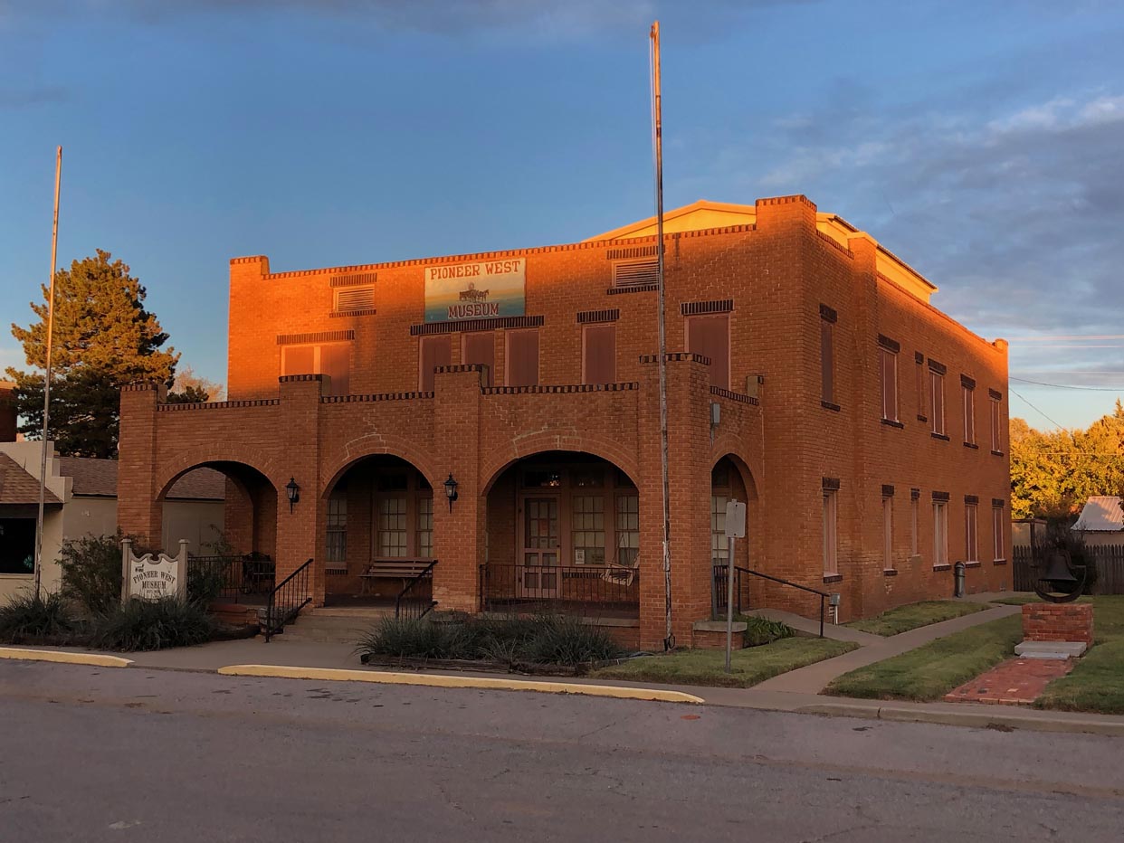
Pioneer West Museum
The Pioneer West Museum, which highlights a diversity of West Texas exhibits, is housed on ...
DetailOklahoma City – Hydro
OklahomaPrinting this description can take a lot of time, so you might want to consider buying commercially available alternatives such as the 8 map set and the EZ66 guide to take along on your trip.
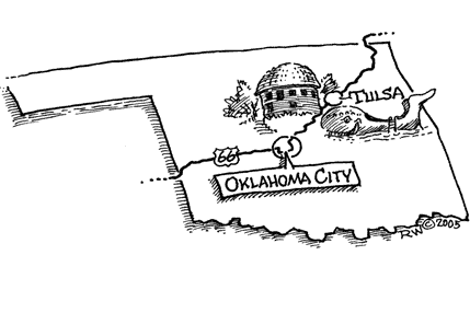
Oklahoma City
Mileage: 0
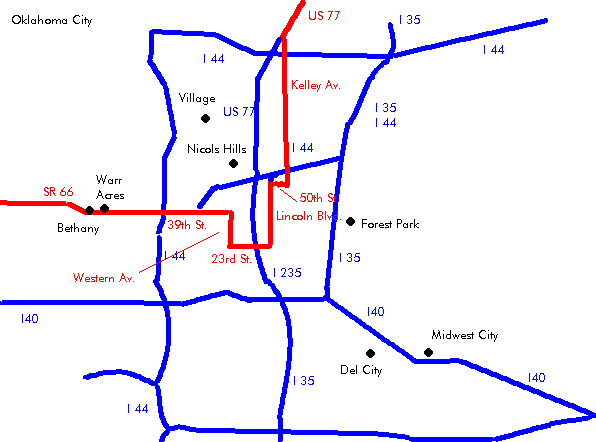
Enter on Lincoln blvd.
Follow Lincoln Blvd. southbound to 23th St.
State Capitol on the left.
Turn right using the exit towards westbound 23rd St.
Cross I-235 (Centennial Expy.).
there are several options to get to 39th street:
Western Ave.
Turn right onto (=north) Western Ave.
Turn right onto (=west) 39th St.
Continue on 39th St.
Turn left onto (=south) Frankford Ave.
Turn next right (=west) onto 38th St.
Turn next right (=north) onto May Ave.
Classen Blvd.
Turn right onto (=north) Classen Blvd.
Turn right onto (=west) 39th St.
Continue on 39th St.
Turn left onto (=south) Frankford Ave.
Turn next right (=west) onto 38th St.
Turn next right (=north) onto May Ave.
May Ave.
Turn right (=north) onto May Ave.
Straight across 39th St.
All
Cross I-44 to the north side on May Ave.
Turn immediately left, entering I-44 westbound.
Use exit 123B (to Grand Blvd.)
Keep left towards OK-66 (War Acres/Bethany)
Cross OK-3 (Lake Hefner Pky.)
Continue west on 39th St. (OK-66).
War Acres
Continue west on 39th St. (OK-66).
Bethany
Continue west on 39th Expy. (OK-66).
Cross straight at the intersection with Council Rd.
Turn next left onto Overholser Dr. after 0.35 miles.
Continue as the road turns right.
Cross the North Canadian River.
Lake Overholser to the left.
Continue along the lake on Overholser Dr.
Bear right at the Y-intersection with 39th St. to curve onto 36th St. westbound.
Continue on 36th St.
Yukon
Continue straight as the road renames to Lakeshore Dr.
At the intersection with Mustang Rd., turn right.
Immediately turn left on the 4 lane Main St. (OK-66).
Continue westbound on Main St. (OK-66).
El Reno
Enter on OK-66 (27th St.).
Continue straight at the intersection with Shepard Ave./BL-40 (US-81) onto OK-66 (US-81, BL-40).
Follow the curve right onto Rock Island Ave, away from 27th St.
Straight across (=north) at the intersection with Elm St.
Turn left (=west) onto Wade St. (OK-66, BL-40, US-81) for 2 blocks.
Turn right (=north) onto Choctaw Ave. (OK-66, BL-40, US-81) for 1 block.
Turn left onto Sunset Dr. (OK-66, BL-40).
Continue on Sunset Dr. (OK-66, BL-40) as it curves right and left.
West of El Reno, OK-66 curves south towards I-40, just before the curve, turn right onto the 2-lane towards Fort Reno on E1020 Rd. (westbound)
Old Reno: El Reno began its life in 1874 further north on the other side of the Canadian River. When the railroad was built further south (due to the city not wanting to pay the bonus), the town ended up moving to the railroad at current El Reno, buildings were moved as well as other belongings.
Fort Reno: There’s a military fort near El Reno. To reach the entrance, turn right on OK-66 towards the north for 2 miles near exit 115 of I40. Fort Reno was established in 1874. It was used protect the personnel of the Cheyenne-Arapaho Agency. Troops from this Forst supervised the 1889 great land run. Till 1947 it was used as an Army remount station. In 1947 it was turned over to the U.S. Department of Agriculture.
Continue on the 2-lane alignment (E-1020 Rd.) towards the west.
After about 4.5 miles at the intersection with US-270:
| pre-1933 | post-1933 El Reno cutoff |
|---|---|
| Turn right (=north) onto Calumet Rd. (US-270).
Follow as Calumet Rd. (US-270) curves left and then right. CalumetTurn left onto US-270 just before the railroad. Continue on US-270 out of Calumet. Continue slight left as US-270 leaves the railroad track KarnsContinue on US-270 westbound. GearyEnter on US-270 (South St.). Turn left onto Broadway Ave. (US-281, OK-8) Continue on US-281 (OK-8) out of Geary Sidetrip: A dirt road that predates Route 66 by a year or so exists to the right of US-281. Do not drive it in winter or when wet: Keep right at the Y-intersection with US-281-Spur onto US-281 (OK-8). The EL Reno cutoff joins from the left (other alignment). The older alignment explained in the note above returns a few hundred feet further from the right |
Continue straight onto E1020 Rd.
At the intersection with US-281-Spur near exit 108, turn left (northwest) onto US-281-Spur. After 2.2 miles, turn left (=west) onto Old US Hwy 66. After 1.85 miles, turn left onto US-281 (OK-8). |
| continue | |
Continue southwest on US-281 (OK-8).
Pony bridge: 38 trusses form a nearly 4000-foot bridge across the Canadian River. Built in 1930s.
Continue on US-281 (OK-8) as it curves right (=west).
Hinton Junction
Continue straight at the intersection with US-281 (OK-8) onto E1020 (Old US Hwy 66).
Sidetrip: Red Rock Canyon State Park is located south on US-281 (OK-8).
Bridgeport
Continue on E1020 Rd. (Old US Hwy. 66).
Abandoned motel at the intersection with N2590 Rd.
Bridgeport is to the north at N2590 Rd. (0.5 miles). See a modern day Ghost Town.
Continue on E1020 Rd. (Old US Hwy 66) westbound.
Multiple old bridges on this stretch of road.
Continue straight as I40 draws closer and E1020 Rd. (Old US Hwy 66 becomes the north service Road.
Hydro
Continue straight at the intersection with OK-58 near exit 88.


