Turn by turn
Tijeras – Grants
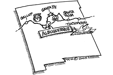
New MexicoPrinting this description can take a lot of time, so you might want to consider buying commercially available alternatives such as the 8 map set and the EZ66 guide to take along on your trip.
| Pre 1937 alignment | Post 1937 alignment |
|---|---|
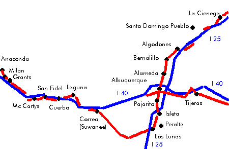
La CienegaIn 2005 there were still open routes through La Bajada Hill, but they’re extremely challenging to drive today (as they were back in 1926-32). It’s the most difficult stretch of road you can encounter on Route 66 today. High clearance 4×4 only. Expect unmaintained roads. Experienced high altitude drivers only. Don’t even think of it in wet weather. Remember even your 4×4 is not built for the same roads as the Ford model T was built for, and the roads are not maintained for many years. Follow Cerrillos Rd. Join I-25 south at exit 278. Some sources suggest the eastern frontage road from exit 276 to the 267 exit, but reaching the soutern frontage road from the exit itself is nearly impossible. One can, however, use exit 271 and cross to the eastern frontage road there. Continue on I-24 at exit 264. Towards the bottom of La Bajada Hill on the 1926-32 alignment: Continue on I-25 southbound. Towards Domingo: Fred Thompsons’ Indian Trading post: check the guestbook. – Right (west ) is Santa Domingo Pueblo. AlgodonesUse exit 248 (to Algodones). Turn right(=northwest) onto NM-474 After 0.3 miles, turn right(=south) NM-313 Continue on NM-313 (El Camino Real, Pan American Central Hwy.) southbound BernalilloContinue on NM-313 (El Camino Real, Pan American Central Hwy.) southbound Straight across onto NM-313 (Camino Del Pueblo, Pan American Central Hwy.) at the intersection with NM-44. Continue on NM-313 (El Camino Real, Pan American Central Hwy.) southbound Continue across the Amafca north Diversion Channel. Continue as NM-313 curves slightly left onto 4th St. Cross under I-40. Turn right (=west) onto Lomas Blvd. (4th st is interrupted further south) Turn left (=south) onto 6th St. Originally 4th St continued south, Some sources prefer 2nd St. instead of 6th. Turn left (=east) onto Central Ave. Turn right (=south) onto 4th St. |
TijerasTurn left at the intersection with NM-14 to stay on NM-333 near exit175. Immediate continue on NM-333 (highway 66 by following the right curve. Straight across at the intersection with NM-337. Continue on NM-333 (Old 66, Highway 66, Route 66) as it follows I-40 to the south. Cross under I-40 as it curves west (no access). CarnuelContinue west on NM333 (Highway 66). Some sources suggest to enter I-40 at exit 170 till exit 167 and continue there on Central Ave. in Albuquerque. Cross I-40 to the south side near exit 170. Continue on NM-333 towards Albuquerque. |
| continue | |
Albuquerque
| Pre 1937 alignment | Post 1937 alignment |
|---|---|
| Heading south on 4th St. south of Central Blvd:
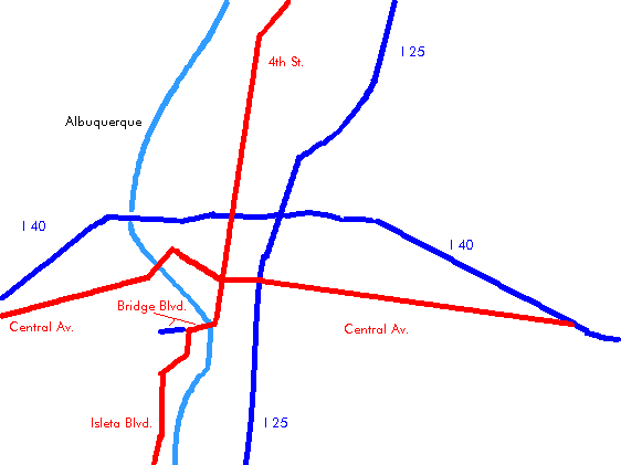
The Albuquerque Museum: 2000 Mountain Rd. NW. Indian Pueblo Cultural Center: 2401 12th St. NW. National Atomic Museum: Kirkland Air Force Base; Building 20358, Wyoming Blvd. Turn right onto Bridge Blvd. Cross the Rio Grande on the Barelas Bridge Continue on Bridge Blvd for 0.3 miles. Turn left onto Isleta Blvd. (NM-314). Follow left onto Isleta Blvd. (NM314) at the intersection with Arenal Rd./Goff Blvd. PajaritoContinue south on Isleta Blvd. (NM-314). Los PallidasContinue south on Isleta Blvd. (NM-314). Cross I-25 at exit 213. IsletaTurn slight left (=south) onto NM-147. Alternatively: continue on NM-314 southbound. Cross the railroad. Follow as NM-147 curves left. Cross the Rio Grande. Isleta PuebloTurn right (=south) onto NM-47. Continue south on NM-47. Bosque FarmsContinue south on Bosque Farms Blvd. (NM-47). Los LunasContinue south on Main St. (NM-47). Continue straight onto NM-6 (Main St.) at the intersection with NM-6. (leave NM-47 as it turns left). Continue on NM-6 (Main St.) as it curves west. Cross I-25 at exit 203. Continue on NM-6 westbound. Route 66 and NM-6 switched numbering in some places during the 1937 realingnment, so take care with old information, as there have been substantial switchings of names. SandiaCross over the railroad. Continue on NM-6 westbound. Rio PuercoContinue on NM-6 westbound. An older alignment of Route 66 is to the left of NM-6, it’s undrivable however, admire from the newer road. South GarciaSouth Garcia is a bit more southeast than NM-6. Continue on NM-6 westbound. SuwaneeContinue on NM-6 westbound. CorreoQuite some maps name this place Suwanee, but you’re through there already. Continue straight on NM-6 at the intersection of Highland Mdws. (Route 66) and NM-6 which curves north. See further left and right at this intersection for old route 66 alignments. (right is a dead-end, left is unpaved). Continue on NM-6 for 1.8 miles. Cross I-40. Join I-40 westbound at exit 126. Unpaved alternative: |
If on the Interstate, take exit 167 (Central Ave./Tramway) and turn right onto Central Ave. once to the south of I-40. Continue straight onto Central Ave. (NM-333) at the intersection with Four Hills Rd. Continue straight onto Central Ave (Route 66) at the intersection with Tramway Blvd. (NM-556). La Puerta Motor Lodge on the left Luna Lodge on the right. Pinon Lodge on the right. Budget 8 Inn (Lo-La-Mi Court) on the left. Bow and Arrow Lodge (Urban Motor Court) on the left. Route 66 Inn (El Jardin Lodge & Cafe) on the left. Route 66 service center on the left. La Mesa court on the right. Tewa Motor Hotel on the right. Desert Sands Motor Hotel on the left. Hiland Theatre on the left. Zia Lodge on the right. De Anza Motor Lodge on the right. Aztec Motel on the right. Nob hill business center on the left. Cross I25. Cross the Railroad. Continue straight onto Central Ave at the intersection with 1st St. Stay with Central Ave. as it bends right at the intersection with 8th St. Route 66 auto detailing on the left. Kimo theater on the right. Lindy’s Coffee Shop on the left. Skip Maisel Indian Jewelry on the left. El Rey Theatre on the left. Bell’s trading post on the right. Stay with Central Ave at the intersection with Lomas Blvd. Stay with Central Ave. as it swings left. Tower Court on the right. Cross the Rio Grande (Old Town Bridge). Continue on Central Ave. as it curves right. 66 Court Motel on the left. Westward Ho motel on the left. Unser garage on the left. Just before exit 149: turn left onto Paseo Del Volcan Rd. Cross I-40 to the north. Turn right onto the northern frontage road (Central Ave, Route 66). Cross the old bridge. This is a 1933 bridge, and it was saved by the New Mexico Historic Route 66 Association. Join the interstate at exit 140. Continue on I-40 at exit 126. Other alignment joins here optionally. Use exit 117 and turn right into Mesita. |
| continue | |
Mesita
Continue west on the north frontage road.
Owl rock on the right 2 miles after Mesita.
Deadman’s curve: a 180-degree bend in the road to the left.
Turn right onto NM-124 (near exit 114).
To the left is Route 66 as well.
Laguna
Continue on NM-124.
Cross the railroad tracks.
Continue on NM-124.
New Laguna
Continue on NM-124.
Paraje
Continue on NM-124.
side trip: Acoma Pueblo, “Sky City” featuring the San Esteban Del Rey Mission is 12 miles south of I-40 on NM-23. Foresee enough time: You must use the bus and must get licenses for each of your cameras at.
Continue on NM-124.
Budville
At the Intersection with Old 66:
| Pre 1937 | Post 1937 |
|---|---|
| Turn right on Old 66.
Continue north on Old 66 for 1 mile. CuberoFollow as the road curves to the left Cubero itself is to the right here. Continue to the west after the curve. Continue Straight a the intersection with BIA-45. Villa De Cubero is to the south here. After 1.1 miles, turn left onto NM-124. |
Continue straight on NM124.
Villa De CuberoStories have it that Ernest Hemmingway wrote here The old man and the sea. Continue on NM-124. |
| continue | |
San Fidel
Continue on NM-124.
Cross over I-40 at exit 96 (McCartys)
Large vehicles ought to join I-40 till exit 89, due to a low underpass further ahead.
McCartys
Continue on the south frontage road (NM-124)
Follow NM-124 through the tunnel to the north side of I-40 (=right)
Turn right (=north) onto NM-117 near exit 89.
Continue onto NM-117 toward Grants.
Cross the railroad.
Grants
enter on Santa Fe Ave.
west of town, cross over the railroad (=follow)
follow NM-122


