Turn by turn
Westbound Springfield
Printing this description can take a lot of time, so you might want to consider buying commercially available alternatives such as the 8 map set and the EZ66 guide to take along on your trip.
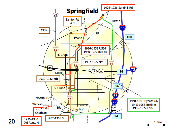
Map courtesy of Stefan Joppich – Legend
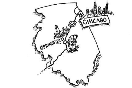
Springfield
In order to make it easier to unerstand, no difference is made between business/bypass and city alignments.
| 1926-1930 | 1930-1932 | 1932-1936 | 1938-1939 | 1937 | post 1940 |
|---|---|---|---|---|---|
| Continue south on BL-55 (Peoria Rd.).
At the intersection with Sand Hill Rd./Chinchilla Ln., a choice of alignments is available: |
Enter Springfield on Walnut Street Rd. (IL-29).
Continue south as th eroad renames to J. David Jones Pkwy (IL-29) Straight across veterans PKwy (IL-4). Left (=east) on N.Grand Ave. Right (=south) on 9th St. |
Continue on Peoria rd.
Left (=southest) on Dirksen Pkwy. Devereux HeightsFollow as Dirksen Pkwy. curves south. StarneContinue south on Dirksen Pkwy. Right (=west) on Adlai Stevenson Dr. SouthlawnContinue on Adlai Stevenson Dr. Left (=south) on 6th St. |
|||
| Right (=west) on Chinchila ln.
Slight left (=southwest) on Johns Rd. Follow slight left (=southwest) onto Sandhill Rd. Right (=southwest) onto Peoria Rd. (BL-55)
|
Continue straight on Peoria Rd. (BL-55) | ||||
| Cross under the railroad.
Left (=south) on Peoria Rd. (BL-55). Do not continue straight on Veterans Pkwy. Straight at the intersection with Taintor Rd. Taintor Rd. was never Route 66. Bill Shea’s Gas Station Museum Left (=south) on 9th St. (BL-55). Cross under the railroad. Continue straight at the intersection with N.Grand Ave. |
|||||
| Continue on 9th St. southbound
At the intersection with Enos Ave. a new choice of alignments is available: |
|||||
| Right (=west) on Enos Ave.
6th was the original alignment but it’s one-way northbound. 5th is part of the Pontiac trail and became Route 66 more to the south at a later date. Left on 5th St. At the intersection with Capitol Ave, a new choice of alignments is available: |
Continue south on 9th St.
Left on Monroe St. for one block Right on S.Grand St. Later city alignments used connections to 5th and 6th a bit more to the south: westbound Spruce St., eastbound: Myrtle St. Left on 5th St. Later alignments used 5th and 6th, earlier alignments only used 6th (one-way northbound) |
||||
| Right (=west) onto Capitol Ave.
Left (=south) onto 2nd St. Right (=west) onto S. Grand Ave. (IL-54). Turn south onto Mac Arthur Blvd. (IL-54, former W. Grand Ave.). JeromeTurn west on Wabash Avenue. (IL-54) [actually Mac Arthur Blvd. blends right into Wabash Ave.] Turn south (=left) on Chatam Road. |
Continue south on 5th St.
Continue straight at the intersection with S.Grand St. |
||||
| Continue south on 5th south of S.Grand.
Bel Aire Motel on 6th just north of Stanford Ave. Follow as modern 5th St. rejoins 6th St. The other 6th St. branching off to the right south of Apple Orchard Rd. is the older alignment but it doesn’t connect to A. Stevenson Dr anymore. Continue straight at the intersection with A. Stevenson Dr.
The older alignment turned east here for one block to turn south on 6th St. Rd. (Yep yet another 6th St.!). It will however not give you access further south back onto the southbound 6th St. you’re already on. |
|||||
| Continue on 6th St. southbound. | |||||
20 miles one way:
Take Jefferson St (IL-97) westbound out of town.
Right on IL-97 north at the intersection with IL-125.
Follow IL-97 north through Salisbury toward Petersburg.


