Turn by turn
Seligman – Topock
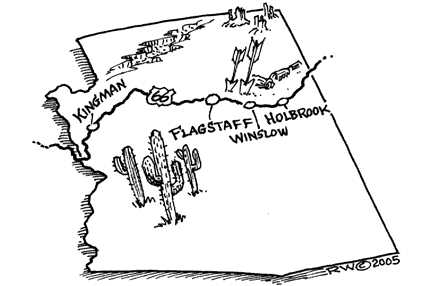
ArizonaPrinting this description can take a lot of time, so you might want to consider buying commercially available alternatives such as the 8 map set and the EZ66 guide to take along on your trip.
Seligman
on AZ-66, and continue on Chino St. as BL-40 joins from exit 123 .
In Seligman, the older Route 66 alignment is Railroad Ave. (1 block closer to the railroad on the left), but the attractions are on the newer alignment.
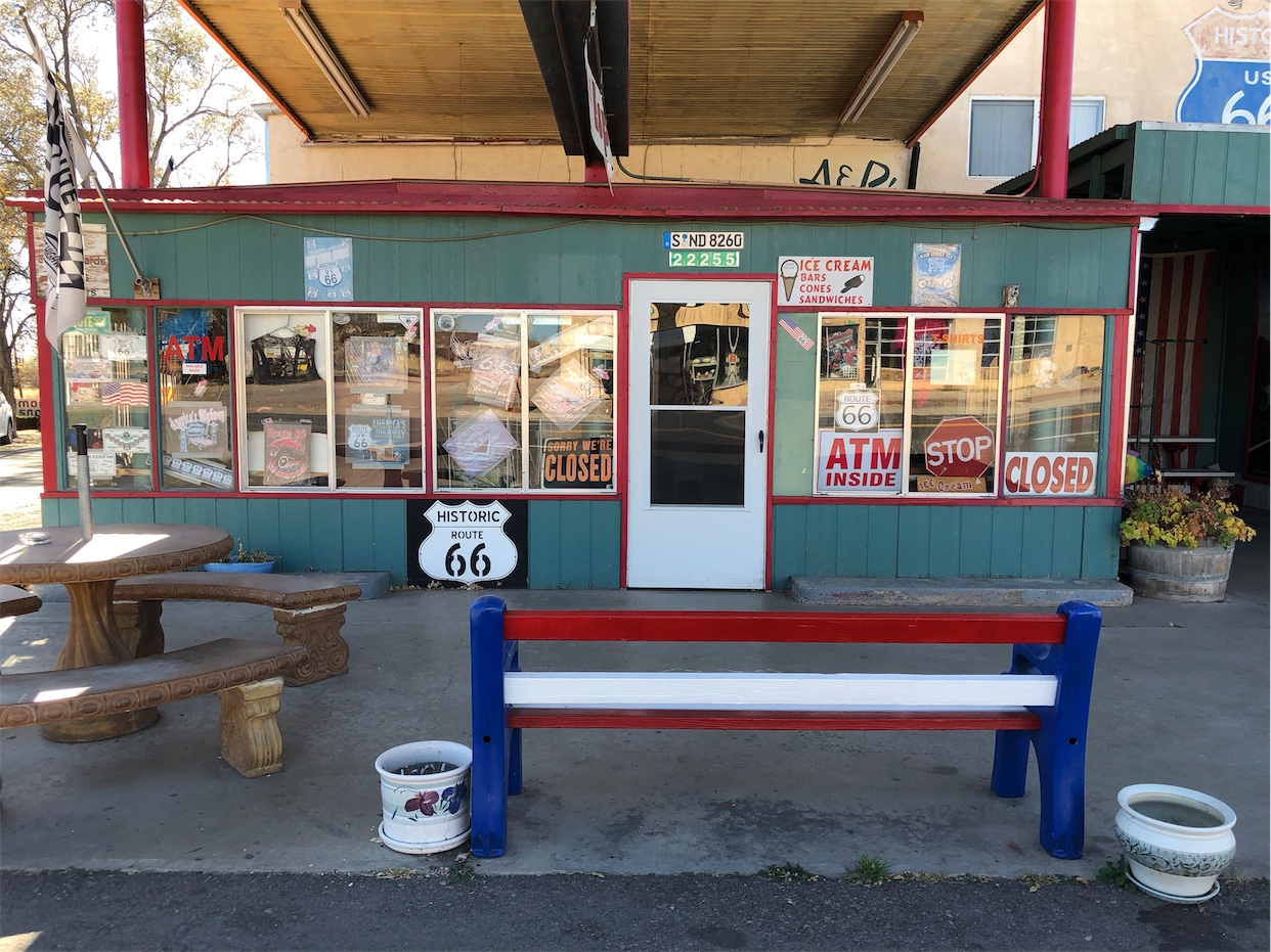
Snow Cap drive, a place full of humor like 2 door knobs on the same side of the door, a sign “sorry we’re open” and the like. Juan Delgadillo runs the Snow Cap.
Angel Delgadillo has his barber shop here. Angel is not just world renowned for promoting Route 66, he’s also the founder of the Arizona Route 66 Association. Angel is retired as a barber, but his shop is now part of the Visitor Center run by Angel and Vilma Delgadillo.
Historic Harvey house.
Leaving Seligman, pass under the western overpass
Continue on AZ-66.
GAS: The stretch to Kingman might be hard to get gas (and certainly from a major brand), if you’re picky about brands or running low, fill up here. We’re leaving I-40 for a while and gas stations will be far less densely available than what you’ve seen so far on Route 66. It’s not a big deal, and it can be driven without a problem, just fill up here to be on the safe side.
Chino
Continue on AZ-66 as it curves right around Chino Point.
note the Pre 1940’s alignment to the right following the telephone poles (undrivable).
Pica
Continue on AZ-66.
The per 1930’s alignment is to the left, but undrivable.
Deer Lodge
Continue on AZ-66.
Deer Lodge Cabins.
Hype Park
Continue on AZ-66.
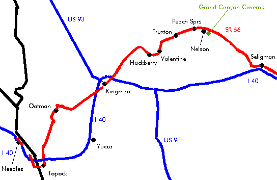
Grand Canyon Caverns Village
Continue on AZ-66.
Grand Canyon Caverns: 21 story elevator descent, always 56 degrees F., formed million of yeas ago, discovers in 1927. It is to the southeast of the village for about 1.5 miles.
Nelson
Continue on AZ-66.
A left on Nelson Rd. (BIA-19) will put you through Nelson and then along the railroad tracks to Peach Springs. This is the pre-1930’s alignment.
2 miles after Nelson Road is another alignment leaving us on the left: the 1930’s till 1940’s one. It’s not accessible.
Watch for the Grand Canyon itself on the right, about 1 mile before entering Peach Springs.
Peach Springs
Continue on AZ-66.
Sidetrip: Diamond Creek Rd. runs to the colorado to see the Grand Canyon. This is the only road to the bottom of the Canyon.
BIA-19 (the pre-1930’s alignment returns here from the left.
Towards Truxton, the pre-1950’s alignment is to the left (inaccessible).
Truxton
Continue on AZ-66.
Gas Station on the right.
Frontier Cafe on the left.
Cozier
Continue on AZ-66.
What’s left of Crozier is now private property.
Valentine
Continue on AZ-66.
There’s another route 66 alignment on the other side of the railroad tracks to the east.
Indian School on the right. Built in 1917, used till 1937, reopened later till 1969.
The red schoolhouse was used by non indian students, built in 1924.
Bert’s Country Dancing.
Straight across at the intersection with CR-141 (Hackberry Road).
The pre-1930’s alignment is on the other side of the railroad tracks.
Hackberry
Continue on AZ-66.
Hackberry general store.
Antares
Continue on AZ-66.
Ranchero Motel
Valle Vista
Town built around a golf course at the time US-40 was being constructed, nothing historic here. The town was built in 1972 around a golf course. This is the newest community on Route 66.
Continue on AZ-66.
Orchards.
Kingman
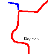
Continue as AZ-66 becomes Andy Devine Ave. as you enter Kingman.
Entering Kingman, pass under I-40 at exit 51.
Quality Inn Motel in Kingman on the local 66 route. The entire place is dedicated to route 66. The entire motel is full of 66 memorabilia. Also, each room in the hotel is named for a person that’s tied to the 66 legend.
The Powerhouse, home to the Route 66 museum.
follow BL-40 (Andy Devine Blvd)
Continue staight at the intersection with 4th St.
Pre 1940’s alignment:
At 4th St., turn left.
Cross the railroad tracks.
Turn slight right onto Old Trails Rd. (at the intersection with Golconda Ave.).
Continue into the canyon for about 3 miles.
Return.
Turn left onto AZ-66 (Historic US-66) at the Y-intersection (away from BL-40) as BL-40 heads back over Ella’s Pl. towards exit 48.
Follow the path of the Railroad through the narrow canyon
McConnico
Follow the path of the Railroad through the narrow canyon
Turn right at I-40 exit 44 onto Shinarump Dr. (CR-10).
Pass under I-40
| Pre 1952 | Post 1952 |
|---|---|
|
This is a mountain road, steep drops, thight curves are to be expected. This difficult routing was chosen because of teh gold found in the mountains. Continue past the on-ramp Turn left onto Oatman Rd. (CR-10). To the right on CR-10 is also Route 66, but it stops at the Interstate 0.7 miles in. Fig SpringsContinue on Oatman Rd. (CR-10). There’s nothing left of Fig Springs. Cool SpringsContinue on Oatman Rd. (CR-10). Cool Spring is ruins only. Cool Spring is in the process of being restored (updated fall 2004). Ed’s CampContinue on Oatman Rd. (CR-10). Ed’s Camp a bit over a mile from Cool Springs, used to house the Kactus Kafe, a gas station and some cabins. All is private property now. 2 miles further west is Shaffer’s Fishbowl Spring. at the top of the stairs rising above the road, a natural spring can be found (into what looks like a bowl made of cement and rock). Sitgraves PassContinue on Oatman Rd. (CR-10). In the old days, cars used to drive up the road in reverse (to get the gas flowing towards the engine), modern cars have a pump to make sure the engine gets fuel. Goad RoadContinue on Oatman Rd. (CR-10). Goal Road was burned down by the owners in 1949 in order to avoid taxes. Goald Road Mine, can be visited (275 feet below Route 66). Continue straight at the intersection with Silver Creek Rd. (CR-155). OatmanSome classify Oatman as a ghost town, but there’s quite some activity here. Hang out a little and you might witness an authentic fake gunfight. The main attraction are the “wild” burros, but they are experienced beggars, don’t feed them bread though, makes them ill afterward. The burros are the offspring of those that worked in the gold mines and were left to care for themselves as the mines closed. Oatman Hotel: Clack Gable and Carol Lombard spent their honeymoon here after getting married in Kingman. Continue on Oatman-Topock Hwy. (CR-153, CR-10). Old TrailsContinue on Oatman-Topock Hwy. (CR-153, CR-10). 2 miles west of Old Trails, bear left at the Y-intersection onto Oatman-Topock Hwy. (Old US-66, CR-10). Golden ShoresContinue on Oatman-Topock Hwy. (CR-10). TopockDon’t look for houses in Topock, all that remains are bridges. Continue on Oatman-Topock Hwy. (CR-10). Topock has been known by many names, a.o. Needles, Powell, Red Rock, … Join I-40 at exit 1. Continue on the southern frontage Road at exit 1 to the west to get closer to the 1916 Old Trails Arch Bridge, now carrying a gas pipe (private property). The story of bridges starts with railroad crossings. The railroad built one of the first steel bridge here (Red Rock Bridge (1890). |
Enter I-40 at exit 44.
Continue on I-40. YuccaContinue on I-40. The southern (eastern) frontage Road in Yucca used to Be Route 66 during till the 1960’s. TopockContinue on I-40 till California. This is also known as the Yucca Bypass, and is driven on I-40. |
| continue | |
Cross into California.


